


Peoh Point Voting District, Kittitas County, Washington
About
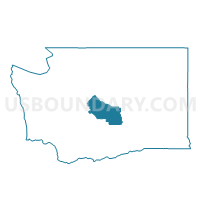
Outline

Summary
| Unique Area Identifier | 687363 |
| Name | Peoh Point Voting District |
| County | Kittitas County |
| State | Washington |
| Area (square miles) | 15.09 |
| Land Area (square miles) | 15.09 |
| Water Area (square miles) | 0.00 |
| % of Land Area | 100.00 |
| % of Water Area | 0.00 |
| Latitude of the Internal Point | 47.16199790 |
| Longtitude of the Internal Point | -120.89580090 |
Maps


Graphs
Select a template below for downloading or customizing gragh for Peoh Point Voting District, Kittitas County, Washington


Neighbors
Neighoring Voting District (by Name) Neighboring Voting District on the Map
- Cle Elum 2 Voting District, Kittitas County, WA
- Cle Elum 4 Voting District, Kittitas County, WA
- South Cle Elum Voting District, Kittitas County, WA
- Teanaway Voting District, Kittitas County, WA
- Thorp Voting District, Kittitas County, WA
- Westside Voting District, Kittitas County, WA